Dataset Pages#
Cook Inlet 2005 Current Survey#
Moored ADCP (NOAA): ADCP survey Cook Inlet 2005
Moored NOAA ADCP surveys in Cook Inlet
ADCP data has been converted to eastward, northward velocities as well as along- and across-channel velocities, in the latter case using the NOAA-provided rotation angle for the rotation. The along- and across-channel velocities are additionally filtered to show the subtidal signal, which is what is plotted in the dataset page.
Dataset description, link to page in CIOFS Hindcast report [TLFD23].
Catalog page, link to page in GitHub repository documentation.
Cook Inlet 2002/2003/2004/2008/2012 Current Survey#
Moored ADCP (NOAA): ADCP survey Cook Inlet, multiple years
Moored NOAA ADCP surveys in Cook Inlet
ADCP data has been converted to eastward, northward velocities as well as along- and across-channel velocities, in the latter case using the NOAA-provided rotation angle for the rotation. The along- and across-channel velocities are additionally filtered to show the subtidal signal, which is what is plotted in the dataset page.
Dataset description, link to page in CIOFS Hindcast report [TLFD23].
Catalog page, link to page in GitHub repository documentation.
Barabara to Bluff 2002-2003#
CTD transects: Barabara to Bluff
Repeat CTD transect from Barabara to Bluff Point in Cook Inlet from 2002 to 2003.
Dataset description, link to page in CIOFS Hindcast report [TLFD23].
Catalog page, link to page in GitHub repository documentation.
CTD Transects 2004-2006 - CMI KBNERR#
CTD Transects, Moored CTD (CMI KBNERR): Six repeat, one single transect, one moored CTD
Seasonality of Boundary Conditions for Cook Inlet, Alaska
During 2004 to 2006 we collected hydrographic measurements along transect lines crossing: 1) Kennedy Entrance and Stevenson Entrance from Port Chatham to Shuyak Island; 2) Shelikof Strait from Shuyak Island to Cape Douglas; 3) Cook Inlet from Red River to Anchor Point; 4) Kachemak Bay from Barbara Point to Bluff Point, and 5) the Forelands from East Foreland to West Foreland. During the third year we added two additional lines; 6) Cape Douglas to Cape Adams, and 7) Magnet Rock to Mount Augustine. The sampling in 2006 focused on the differences in properties during the spring and neap tide periods.
CTD profiles 2004-2005 - CMI UAF seems to be transect 5 of this project.
Part of the project: Seasonality of Boundary Conditions for Cook Inlet, Alaska Steve Okkonen Principal Investigator Co-principal Investigators: Scott Pegau Susan Saupe Final Report OCS Study MMS 2009-041 August 2009 Report: https://researchworkspace.com/files/39885971/2009_041.pdf

Dataset description, link to page in CIOFS Hindcast report [TLFD23].
Catalog page, link to page in GitHub repository documentation.
CTD profiles 2004-2005 - CMI UAF#
CTD Transect (CMI UAF): from East Foreland Lighthouse
Seasonality of Boundary Conditions for Cook Inlet, Alaska: Transect (3) at East Foreland Lighthouse.
9 CTD profiles at stations across 10 cruises in (approximately) the same locations. Approximately monthly for summer months, 2004 and 2005.
Part of the project: Seasonality of Boundary Conditions for Cook Inlet, Alaska Steve Okkonen Principal Investigator Co-principal Investigators: Scott Pegau Susan Saupe Final Report OCS Study MMS 2009-041 August 2009 Report: https://researchworkspace.com/files/39885971/2009_041.pdf
Dataset description, link to page in CIOFS Hindcast report [TLFD23].
Catalog page, link to page in GitHub repository documentation.
CTD profiles 2012-2021 - GWA#
CTD Transects (GWA): Six repeat transects in Cook Inlet
The Kachemak Bay Research Reserve (KBRR) and NOAA Kasitsna Bay Laboratory jointly work to complete oceanographic monitoring in Kachemak Bay and lower Cook Inlet, in order to provide the physical data needed for comprehensive restoration monitoring in the Exxon Valdez oil spill (EVOS) affected area. This project utilized small boat oceanographic and plankton surveys at existing KBRR water quality monitoring stations to assess spatial, seasonal and inter-annual variability in water mass movement. In addition, this work leveraged information from previous oceanographic surveys in the region, provided environmental information that aided a concurrent Gulf Watch benthic monitoring project, and benefited from a new NOAA ocean circulation model for Cook Inlet.
Surveys are conducted annually along five primary transects; two in Kachemak Bay and three in lower Cook Inlet, Alaska. Oceanographic data were collected via vertical CTD casts from surface to bottom, zooplankton and phytoplankton tows were made in the upper water column, and seabird and marine mammal observations were performed opportunistically. We also collect meteorological data and water quality measurements in Homer Harbor and Anchor Point year-round at stations as part of our National Estuarine Research Reserve (NERR) System-wide Monitoring program in Seldovia and Homer harbors, and in ice-free months at a mooring near the head of Kachemak Bay.
Project files and further description can be found here: https://gulf-of-alaska.portal.aoos.org/#metadata/4e28304c-22a1-4976-8881-7289776e4173/project
Dataset description, link to page in CIOFS Hindcast report [TLFD23].
Catalog page, link to page in GitHub repository documentation.
CTD profiles 2003-2006 - OTF KBNERR#
CTD Transect (OTF KBNERR): Repeated from Anchor Point
CTD Transect Across Anchor Point, for GEM Project 030670.
This project used a vessel of opportunity to collect physical oceanographic and fisheries data at six stations along a transect across lower Cook Inlet from Anchor Point (AP) to the Red River delta each day during July. Logistical support for the field sampling was provided in part by the Alaska Department of Fish and Game which has chartered a drift gillnet vessel annually to fish along this transect providing inseason projections of the size of sockeye salmon runs entering Cook Inlet. This project funded collection of physical oceanographic data on board the chartered vessel to help identify intrusions of the Alaska Coastal Current (ACC) into Cook Inlet and test six hypotheses regarding effects of changing oceanographic conditions on migratory behavior and catchability of sockeye salmon entering Cook Inlet. In 2003-2007, a conductivity-temperature-depth profiler was deployed at each station. In 2003-2005, current velocities were estimated along the transect using a towed acoustic Doppler current profiler, and salmon relative abundance and vertical distribution was estimated using towed fisheries acoustic equipment.
Willette, T.M., W.S. Pegau, and R.D. DeCino. 2010. Monitoring dynamics of the Alaska coastal current and development of applications for management of Cook Inlet salmon - a pilot study. Exxon Valdez Oil Spill Gulf Ecosystem Monitoring and Research Project Final Report (GEM Project 030670), Alaska Department of Fish and Game, Commercial Fisheries Division, Soldotna, Alaska.
Report: https://evostc.state.ak.us/media/2176/2004-040670-final.pdf Project description: https://evostc.state.ak.us/restoration-projects/project-search/monitoring-dynamics-of-the-alaska-coastal-current-and-development-of-applications-for-management-of-cook-inlet-salmon-040670/
Dataset description, link to page in CIOFS Hindcast report [TLFD23].
Catalog page, link to page in GitHub repository documentation.
CTD time series UAF#
CTD Transects (UAF): Repeated in central Cook Inlet
Observations of hydrography and currents in central Cook Inlet, Alaska during diurnal and semidiurnal tidal cycles
Surface-to-bottom measurements of temperature, salinity, and transmissivity, as well as measurements of surface currents (vessel drift speeds) were acquired along an east-west section in central Cook Inlet, Alaska during a 26-hour period on 9-10 August 2003. These measurements are used to describe the evolution of frontal features (tide rips) and physical properties along this section during semidiurnal and diurnal tidal cycles. The observation that the amplitude of surface currents is a function of water depth is used to show that strong frontal features occur in association with steep bathymetry. The positions and strengths of these fronts vary with the semidiurnal tide. The presence of freshwater gradients alters the phase and duration of tidal currents across the section. Where mean density-driven flow is northward (along the eastern shore and near Kalgin Island), the onset of northward tidal flow (flood tide) occurs earlier and has longer duration than the onset and duration of northward tidal flow where mean density-driven flow is southward (in the shipping channel). Conversely, where mean density-driven flow is southward (in the shipping channel), the onset of southward tidal flow (ebb tide) occurs earlier and has longer duration than the onset and duration of southward tidal flow along the eastern shore and near Kalgin Island.
Observations of hydrography and currents in central Cook Inlet, Alaska during diurnal and semidiurnal tidal cycles Stephen R. Okkonen Institute of Marine Science University of Alaska Fairbanks Report: https://www.circac.org/wp-content/uploads/Okkonen_2005_hydrography-and-currents-in-Cook-Inlet.pdf
Dataset description, link to page in CIOFS Hindcast report [TLFD23].
Catalog page, link to page in GitHub repository documentation.
CTD profiles 2005 - NOAA#
CTD Profiles (NOAA): across Cook Inlet
CTD Profiles from NOAA.
Dataset description, link to page in CIOFS Hindcast report [TLFD23].
Catalog page, link to page in GitHub repository documentation.
Kachemak Kuletz 2005-2007#
CTD Profiles (Kachemak Kuletz 2005-2007)
CTD Profiles in Cook Inlet
Dataset description, link to page in CIOFS Hindcast report [TLFD23].
Catalog page, link to page in GitHub repository documentation.
KB small mesh 2006#
CTD Profiles (KB small mesh 2006)
CTD Profiles in Cook Inlet
Dataset description, link to page in CIOFS Hindcast report [TLFD23].
Catalog page, link to page in GitHub repository documentation.
Drifters: Ecosystems & Fisheries-Oceanography Coordinated Investigations (EcoFOCI)#
Drifters (EcoFOCI)
EcoFOCI Project.
As described on the main project website for EcoFOCI:
We study the ecosystems of the North Pacific Ocean, Bering Sea and U.S. Arctic to improve understanding of ecosystem dynamics and we apply that understanding to the management of living marine resources. EcoFOCI scientists integrate field, laboratory and modeling studies to determine how varying biological and physical factors influence large marine ecosystems within Alaskan waters.
EcoFOCI is a joint research program between the Alaska Fisheries Science Center (NOAA/ NMFS/ AFSC) and the Pacific Marine Environmental Laboratory (NOAA/ OAR/ PMEL).
Drifter data are being pulled from this webpage: https://www.ecofoci.noaa.gov/drifters/efoci_drifterData.shtml which also has a plot available for each drifter dataset.
Several years of EcoFOCI drifter data are also available in a private Research Workspace project: https://researchworkspace.com/project/41531085/files.
Catalog page, link to page in GitHub repository documentation.
Drifters (UAF), multiple projects#
Drifters (UAF)
Drifters run by Mark Johnson and others out of UAF with various years and drogue depths.
2003: 7.5m (Cook Inlet)
2004: 5m (Cook Inlet)
2005: 5m, 80m (Cook Inlet)
2006: 5m (Cook Inlet)
2012: 1m (Cook Inlet), 15m (Cook Inlet)
2013: 1m (Cook Inlet), 15m (Cook Inlet)
2014: 1m (Cook Inlet)
2019: 1m (Kachemak Bay, Lynn Canal)
2020: 1m (Kachemak Bay, Lynn Canal)
Descriptive summary of later drifter deployment: https://www.alaska.edu/epscor/about/newsletters/May-2022-feature-current-events.php, data portal: https://ak-epscor.portal.axds.co/
Catalog page, link to page in GitHub repository documentation.
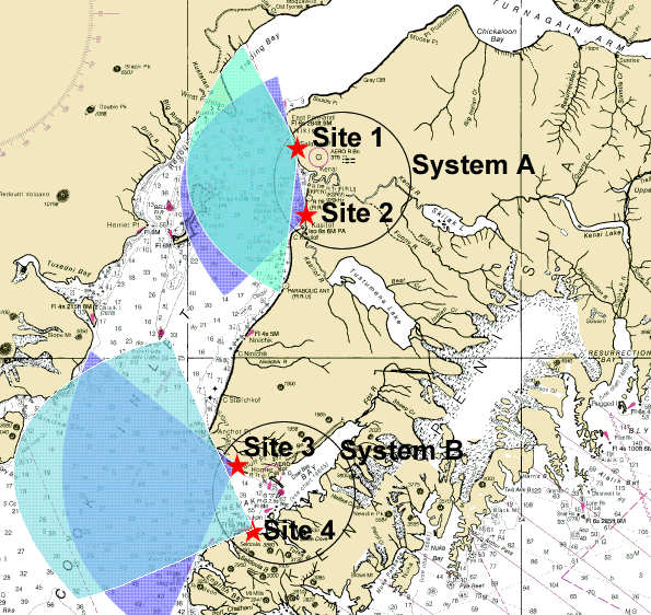
HF Radar - UAF#
HF Radar (UAF)
HF Radar from UAF.
Files are:
Upper Cook Inlet (System A): 2002-2003 and 2009
Lower Cook Inlet (System B): 2006-2007
Data variables available include tidally filtered and weekly averaged along with tidal constituents calculated from hourly data.
Several new datasets were derived in 2024 with the CIOFS freshwater project which narrow the full time datasets (lower-ci_system-B_2006-2007.nc and upper-ci_system-A_2002-2003.nc) in time to just 2003 and 2006, respectively, before running processing in Research Workspace and are otherwise identical. See processing notebook https://researchworkspace.com/file/44879475/add_variables_to_notebooks_limited_time_range.ipynb:
lower-ci_system-B_2006_subtidal_daily_mean.nc
lower-ci_system-B_2006_tidecons_base.nc
lower-ci_system-B_2006_subtidal_weekly_mean.nc
upper-ci_system-A_2003_subtidal_daily_mean
upper-ci_system-A_2003_tidecons_base
upper-ci_system-A_2003_subtidal_weekly_mean.nc
Some of the data is written up in reports:
https://espis.boem.gov/final%20reports/5009.pdf
https://www.govinfo.gov/app/details/GOVPUB-I-47b721482d69e308aec1cca9b3e51955
Dataset description, link to page in CIOFS Hindcast report [TLFD23].
Catalog page, link to page in GitHub repository documentation.
Moorings from Alaska Ocean Observing System (AOOS)/ Coastal Data Information Program (CDIP)#
Moorings (CDIP): Lower and Central Cook Inlet, Kodiak Island
Moorings from AOOS/CDIP
Dataset description, link to page in CIOFS Hindcast report [TLFD23].
Catalog page, link to page in GitHub repository documentation.
Mooring from CIRCAC#
Mooring (CIRCAC): Central Cook Inlet Mooring
Central Cook Inlet Mooring from: Seasonality of Boundary Conditions for Cook Inlet, Alaska
CIRCAC is the Cook Inlet Regional Citizens Advisory Council. It was funded by MMS (pre-BOEM), OCS Study MMS 2009-041 funneled through the Coastal Marine Institute (University of Alaska Fairbanks).
This mooring was damaged so it was removed.
Part of the project: Seasonality of Boundary Conditions for Cook Inlet, Alaska Steve Okkonen Principal Investigator Co-principal Investigators: Scott Pegau Susan Saupe Final Report OCS Study MMS 2009-041 August 2009 Report: https://researchworkspace.com/files/39885971/2009_041.pdf
Dataset description, link to page in CIOFS Hindcast report [TLFD23].
Catalog page, link to page in GitHub repository documentation.
Moorings from Kachemak Bay National Estuarine Research Reserve (KBNERR)#
Moorings (KBNERR): Lower Cook Inlet Mooring
Lower Cook Inlet Mooring from: Seasonality of Boundary Conditions for Cook Inlet, Alaska
CIRCAC is the Cook Inlet Regional Citizens Advisory Council. It was funded by MMS (pre-BOEM), OCS Study MMS 2009-041 funneled through the Coastal Marine Institute (University of Alaska Fairbanks).
Part of the project: Seasonality of Boundary Conditions for Cook Inlet, Alaska Steve Okkonen Principal Investigator Co-principal Investigators: Scott Pegau Susan Saupe Final Report OCS Study MMS 2009-041 August 2009 Report: https://researchworkspace.com/files/39885971/2009_041.pdf
Dataset description, link to page in CIOFS Hindcast report [TLFD23].
Catalog page, link to page in GitHub repository documentation.
Moorings from Kachemak Bay National Estuarine Research Reserve (KBNERR)#
Moorings (KBNERR): Kachemak Bay: Bear Cove, Seldovia
Moorings from Kachemak Bay National Estuarine Research Reserve (KBNERR)
Station mappings from AOOS/ERDDAP to KBNERR station list:
nerrs_kacsdwq :: kacsdwq
nerrs_kacsswq :: kacsswq
cdmo_nerrs_bearcove :: This is a different station than kacbcwq, which was active 2002-2003 while this is in 2015. They are also in different locations.
More information: https://accs.uaa.alaska.edu/kbnerr/
Dataset description, link to page in CIOFS Hindcast report [TLFD23].
Catalog page, link to page in GitHub repository documentation.
Historical moorings from Kachemak Bay National Estuarine Research Reserve (KBNERR)#
Moorings (KBNERR): Historical, Kachemak Bay
Historical moorings from Kachemak Bay National Estuarine Research Reserve (KBNERR)
More information: https://accs.uaa.alaska.edu/kbnerr/
Dataset description, link to page in CIOFS Hindcast report [TLFD23].
Catalog page, link to page in GitHub repository documentation.
Moorings from Kachemak Bay National Estuarine Research Reserve (KBNERR)#
Moorings (KBNERR): Kachemak Bay, Homer stations
Moorings from Kachemak Bay National Estuarine Research Reserve (KBNERR)
Station mappings from AOOS/ERDDAP to KBNERR station list:
nerrs_kachdwq :: kachdwq
homer-dolphin-surface-water-q :: kachswq
nerrs_kach3wq :: kach3wq
More information: https://accs.uaa.alaska.edu/kbnerr/
Dataset description, link to page in CIOFS Hindcast report [TLFD23].
Catalog page, link to page in GitHub repository documentation.
Moorings from NOAA#
Moorings (NOAA): across Cook Inlet
Moorings from NOAA
Geese Island, Sitkalidak Island, Bear Cove, Anchorage, Kodiak Island, Alitak, Seldovia, Old Harbor, Boulder Point, Albatross Banks, Shelikof Strait
Dataset description, link to page in CIOFS Hindcast report [TLFD23].
Catalog page, link to page in GitHub repository documentation.
Moorings from University of Alaska Fairbanks (UAF)#
Moorings (UAF): Kodiak Island, Peterson Bay
Moorings from UAF
Dataset description, link to page in CIOFS Hindcast report [TLFD23].
Catalog page, link to page in GitHub repository documentation.